Canvas is the key to optimizing catastrophe management. Powerful claims analytics for insurance help insurers act with agility to best support policyholders during catastrophe situations. Enable your claims management and field response teams to geo-visualize claims and policy locations in the context of internal and external data with Canvas.
Proactively reach out to policyholders likely to be impacted by catastrophes. Anticipate, confirm, and prioritize claims based on peril, geography, and intensity. Run "what-if" scenarios with searchable, actionable, and interactive map-based layers for perils such as hail, wind, tornado, lightning, and wildfire.
Follow a Triage Strategy
Leverage data-driven analysis to direct field adjusters and vendors to the hardest-hit areas. Identify insurance claims with possible errors to maximize reinsurance recovery efforts. Recognize potentially fraudulent claims amid mass claims processing with weather discrepancy alerts in ClaimCenter.
Fast Time to Value
Using ClaimCenter? Canvas can be easily enabled — no project, no services engagement, and no need for external consultants. Geo-visualize claims and policy data along with peril severity. Improve communications between the office and field personnel.
Actionable, Searchable, Interactive Geo-Visualization of Perils
Visualize claims and policy information overlaid with weather phenomena and mapped in a heatmap format. Drill down into detailed, location-specific data.
HAIL
WIND
TORNADO
LIGHTNING
WILDFIRE
WATER
EARTHQUAKE
STORM SURGE
Learn More About Canvas. Request a Call, Schedule a Demo, or Ask Us a Question.
An Unmatched Commitment to Our Customers
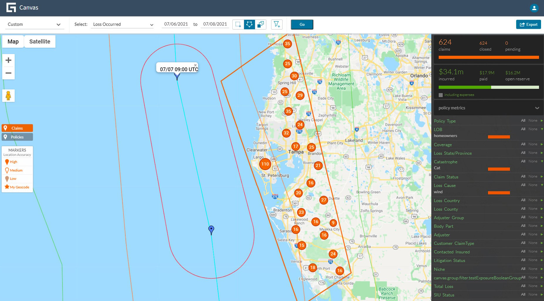
“With Canvas we are able to plot where our policies are in relation to the wildfire and proactively reach out to our policyholders to tell them what coverages are provided if they’re temporarily forced from their homes. People really appreciate that.”
James Kaufmann, Former SVP, Claims, California Casualty Insurance
Guidewire Canvas enables claims management and catastrophe response teams to geo-visualize claims and policy locations in the context of other internal and external data.
While staying at home means increased entertainment streaming, puzzle-playing, and family time, it also means less time on the road and fewer miles driven.